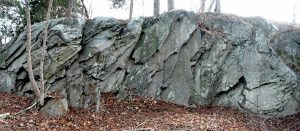
A prominent landmark along the Satucket River, Sachem Rock is a large outcropping of bedrock called Wonnocoote (Wonnocooto) by the Pokanokets who inhabited the area before 1649. Shortened to “Cootah Hill” in the early part of the 20th century, the rock apparently acquired the name Sachem or Sachem’s Rock as early as 1800. Satucket is an ancient word meaning “the place between rivers” or alternately “the place where rivers meet,” the Satucket and Matfield Rivers, which merge in the southern portion of today’s East Bridgewater to form the Town River, which in turn flows south through Bridgewater, ultimately joining the Taunton River.
Two major ancient trails, the Mattakeeset and Satucket Paths, linking the tribal populations to the north with those to the east and south, converged at the fording place. In addition, the Satucket River was part of a Pokanoket canoe route from Scituate in the north part of the region to Dighton Rock in the south. Thus when traveling by water or by land from and to the north, south and east, Native people would have passed close by Sachem Rock..


After a period of negotiations with the local Native authorities, Duxbury representatives Myles Standish, Samuel Nash and Constant Southworth obtained a deed for the Indian land within the Duxbury New Plantation from the Massasoit Ousamequin on March 23, 1649. Massasoit himself had chosen the site where the transaction was to take place, and signed the deed for the land with a mark in the shape of a hand. The territory conveyed on that day was considerably larger than the original eight-mile grant recommended by colonial authorities. The deed specified it to be fourteen miles square—extending seven miles north, east, south and west from the fishing weir on the Satucket. In payment, the sachem received “7 coats, . . . 9 hatchets, 8 hoes, 20 knives, 4 moose skins, and 10 and a half yds of cotton.”


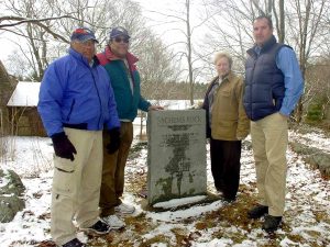
The rock. which appears at the back of the above photo (click to enlarge), is located on the north part of the Sachem Farm property, now owned by the Town of East Bridgewater. The site is understood to have held great cultural significance to the Indigenous people. It lay in the heart of an area where much Native activity took place, and its broad, flat summit is said to have been the site where tribal councils were held. It commanded a sweeping view of the surrounding area, and thus it would also have been a visual landmark for travelers.


Click on above graphics to see a current map of the area and the original document signed by the Massasoit Ousamequin, the first deed signed between colonists and Native people in North America. The land around Sachem Rock was settled by 1665, with a farm and gristmill nearby on the Satucket River, and has seen agricultural uses ever since.